Map Graph

Visayas

Archipelago in the Philippines

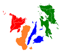
The Visayas, or the Visayan Islands, are one of the three principal geographical divisions of the Philippines, along with Luzon and Mindanao. Located in the central part of the archipelago, it consists of several islands, primarily surrounding the Visayan Sea, although the Visayas are also considered the northeast extremity of the entire Sulu Sea. Its inhabitants are predominantly the Visayan peoples.

Read article
File:Visayas_Red.pngFile:Reports_of_the_missionary_and_benevolent_boards_and_committees_to_the_General_Assembly_of_the_Presbyterian_Church_in_the_United_States_of_America_(1920)_(14769325962).jpgFile:Children_Partaking_In_The_Kalibo_Ati-Atihan_Festival,_Philippines.jpgFile:SINULOG_FESTIVAL_CONTINGENTS_IN_STREET_DANCE_01.jpgFile:Visayas_in_June_2024.pngFile:Visayas_regions.PNG
Top Questions
AI generated

List the top facts about Visayas

Summarize this article

What is the single most intriguing fact about Visayas?

Are there any controversies surrounding Visayas?

More questions