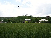
Vardenik
Place in Gegharkunik, ArmeniaVardenik is a village in the Martuni Municipality of the Gegharkunik Province of Armenia, that sits along the Vardenis River. The cyclopean fort ruins of Kaftarli are located 3 km south of the village, with petroglyphs being present downhill along the bank of the river. Some churches and shrines can be found in the vicinity. The village is the largest rural community in Armenia by population.
Read article


Top Questions
AI generatedMore questions
Nearby Places

Artsvanist
Place in Gegharkunik, Armenia

Astghadzor
Place in Gegharkunik, Armenia

Zolakar
Place in Gegharkunik, Armenia
Karmirkharab
Place in Gegharkunik, Armenia
Tsovinar, Armenia
Place in Gegharkunik, Armenia
Verkhnyaya Gezaldara
Place in Gegharkunik, Armenia

Vanevan Monastery

St. Sarkis Church (Tsovinar, Gegharkunik, Armenia)