Trigono
Municipal unit in GreeceTrígono is a former municipality in the Evros regional unit, East Macedonia and Thrace, Greece. Since the 2011 local government reform, it is part of the municipality Orestiada, of which it is a municipal unit. The municipal unit has an area of 392.538 km2. The seat of the municipality was in Dikaia. The municipality was created in 1997 under the Capodistrian Plan. Trigono is the country's northernmost municipal unit, situated in the triangle between the rivers Evros and Ardas. It borders Bulgaria to the north and west, and Turkey to the northeast. The nearest cities are Svilengrad (Bulgaria) to the north, Edirne (Turkey) to the east, and Orestiada to the southeast. The area consists mainly of low hills, with plains in the river valleys, and higher elevations up to 400 m towards the west.
Read article


Top Questions
AI generatedMore questions
Nearby Places

Battle of Maritsa
14th-century battle of the Serbian–Ottoman Wars
Ptelea, Evros
Village in East Macedonia and Thrace, Greece
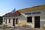
Ormenio
Community in Greece
Dikaia
Community in Greece
Generalovo
Village in Haskovo Province, Bulgaria
Dikaia railway station
Railway station in Greece
Ormenio railway station
Railway station in Greece
Ptelea railway station
Railway station in Eastern Macedonia and Thrace, Greece