Tangkuban Perahu
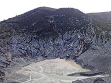
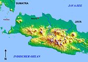
Stratovolcano in West JavaTangkuban Perahu is a stratovolcano 30 km north of the city of Bandung, the provincial capital of West Java, Indonesia. It erupted in 1826, 1829, 1842, 1846, 1896, 1910, 1926, 1929, 1952, 1957, 1961, 1965, 1967, 1969, 1983, 2013 and 2019. It is a popular tourist attraction where tourists hike or ride to the edge of the crater to view the hot water springs and boiling mud up close, and buy eggs cooked on the hot surface. Together with Mount Burangrang and Bukit Tunggul, it is a remnant of the ancient Mount Sunda after the plinian eruption caused the Caldera to collapse.
Read article
Top Questions
AI generatedMore questions


