Sugarloaf Knob
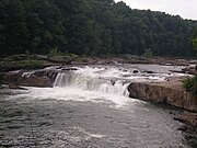
Sugarloaf Knob is a well-known summit within Ohiopyle State Park on the south end of the Laurel Ridge. This mountain has a unique profile and can easily be recognized at different lookouts in the park and surrounding area. The Youghiogheny River cuts beneath the "knob" and Laurel Hill creating a 1,700-foot (520 m) deep chasm. The highest peak in the area is the south end of the Laurel Hill Ridge as it reaches 2,920 ft (890 m) above sea level.
Read article

Top Questions
AI generatedMore questions
Nearby Places
Ohiopyle, Pennsylvania
Borough in Pennsylvania, United States

Ohiopyle State Park

Cucumber Run (Youghiogheny River tributary)
Stream in Pennsylvania, USA

Meadow Run (Youghiogheny River tributary)
Stream in Pennsylvania, USA
Sheepskin Run
Stream in Pennsylvania, USA
Rock Spring Run (Youghiogheny River tributary)
Stream in Pennsylvania, USA
Lick Run (Youghiogheny River tributary)
Stream in Pennsylvania, USA
Camp Run (Youghiogheny River tributary)
Stream in Pennsylvania, USA