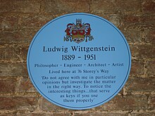
Storey's Way
Road in Cambridge, EnglandStorey's Way is a mainly residential road, approximately 650 metres to the west of the city centre in Cambridge, England. It falls within the Castle Electoral Ward of Cambridge City Council, and feeds on to the major arterial roads Huntingdon Road to the north and Madingley Road to the west.
Read article
Top Questions
AI generatedMore questions
Nearby Places

Churchill College, Cambridge
College of the University of Cambridge

Fitzwilliam College, Cambridge
College of the University of Cambridge

Murray Edwards College, Cambridge
College of the University of Cambridge

Cambridgeshire and Isle of Ely

Cam FM
Student-run radio station at the University of Cambridge and Anglia Ruskin University

Ascension Parish Burial Ground
Cemetery in Cambridge, England

Churchill Archives Centre
University of Cambridge document repository

The Women's Art Collection
Modern art museum in Cambridge, England


