Staplehurst
Human settlement in EnglandStaplehurst is a town and civil parish in the borough of Maidstone in Kent, England, 9 miles (14 km) south of the town of Maidstone and with a population of 6,003. The town lies on the route of a Roman road, which is now incorporated into the course of the A229. The name Staplehurst comes from the Old English 'stapol' meaning a 'post, pillar' and 'hyrst', as a 'wooded hill'; therefore, 'wooded-hill at a post', a possible reference to a boundary marker at the position of All Saints' church atop the hill along the road from Maidstone to Cranbrook. The parish includes the hamlet of Hawkenbury.
Read article


Top Questions
AI generatedMore questions
Nearby Places

Staplehurst railway station
Railway station in Kent, England

South Eastern Main Line
Major long-distance railway line in south-east England
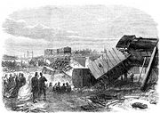
Staplehurst rail crash
Railway accident in Kent, England, in 1865
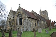
All Saints Church, Staplehurst
Church in Kent, England
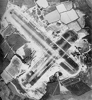
RAF Staplehurst
World War II airfield in England

1930 Air Union Farman Goliath crash
1930 crash caused by tailplane structural failure
Marden Airfield
Airport in Staplehurst, Kent
Staplehurst Monarchs F.C.
Football club