Standlake
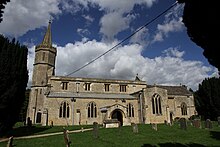
Human settlement in EnglandStandlake is a village and civil parish in West Oxfordshire about 5 miles (8 km) southeast of Witney and 7 miles (11 km) west of Oxford, England. The parish includes the hamlet of Brighthampton. The 2011 Census recorded the parish's population as 1,497. The River Windrush flows past the village and with its tributary Medley Brook it forms much of the eastern boundary of the parish. The western boundary has been subject to changes and disputes in past centuries. It now follows Brighthampton Cut, an artificial land drain dug in the 19th century. The Windrush joins the River Thames at Newbridge just over 1 mile (1.6 km) to the south.south.
Read article
Top Questions
AI generatedMore questions
Nearby Places

River Windrush
River in England

Northmoor, Oxfordshire
Human settlement in England

New Bridge, River Thames
Bridge in Oxfordshire

Brighthampton
Human settlement in England

Mulberry Bush School
Non-maintained special school in Witney, Oxfordshire, England

St Giles' Church, Standlake
Church in Oxfordshire, United Kingdom

Devil's Quoits
Neolithic henge in Oxfordshire, England
RAF Stanton Harcourt


