Stalling Busk
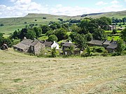
Hamlets in North Yorkshire, EnglandStalling Busk is one of three settlements around Semer Water in the county of North Yorkshire in the small dale of Raydale just off from Wensleydale, England. The village lies to the immediate south of the lake, at 1,080 feet (330 m) above sea level. The name of the settlement derives from a combination of Old French (estalon) and Old Norse (buskr), which means the stallion's bush. The village was also known as Stallen Busk, and is commonly referred to by locals as just Busk. Although the village is not mentioned in the Domesday Book, archaeological evidence points to the area being inhabited during the Iron and Bronze ages.
Read article

Top Questions
AI generatedMore questions
Nearby Places

Semerwater
Lake in North Yorkshire, England
Countersett
Settlement in North Yorkshire, England

Marsett
Hamlets in North Yorkshire, England

Raydale
Valley in the Yorkshire Dales, England

St Matthew's Church, Stalling Busk
Church in Stalling Busk, England
Countersett Hall
House in Bainbridge, North Yorkshire, England

Old St Matthew's Church, Stalling Busk
Ruined church in North Yorkshire, England
Marsett Rigg
Protected area of North Yorkshire