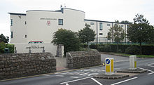
St Saviour, Jersey
Jersey parishSt Saviour is a parish of Jersey in the Channel Islands. It is located directly east of St Helier. It has a population of 13,580. It has a land surface area of 3.6 square miles and has a very small coastline at Le Dicq.
Read article
Top Questions
AI generatedMore questions
Nearby Places

St Michael's Preparatory School
Preparatory school in Channel Islands
JE postcode area
Postcode area within the United Kingdom

Jersey College for Girls
Girls' fee-paying school in Saint Saviour, Jersey

Grainville School
School in Parish of St Saviour, Jersey

Government House, Jersey
Official residence of the Lieutenant Governor of Jersey
Grainville Cricket Ground
Cricket ground in Jersey.

Beaulieu Convent School
Independent all-girls catholic school in St Helier, Jersey
Grouville F.C.
Association football club in Jersey


