Spurwink River
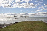
River in the United StatesThe Spurwink River is a 4.6-mile-long (7.4 km) primarily tidal river in Cumberland County, Maine. It rises in the town of Cape Elizabeth and flows west, then southwest, through salt marshes to its mouth at the Atlantic Ocean. It is bridged by Maine State Route 77 at the river's approximate halfway point. From a point shortly above the bridge to the river's mouth, it forms the boundary between Cape Elizabeth to the east and the town of Scarborough to the west. The river's mouth is at the Scarborough village of Higgins Beach.
Read article
.jpg)

Top Questions
AI generatedMore questions
Nearby Places

Nonesuch River
River in United States of America

Higgins Beach
Place in Maine, United States

Prouts Neck
Peninsula in Maine, United States

Scarborough, Maine
Town in the state of Maine, United States

Crescent Beach State Park
State park in Cumberland County, Maine
Libby River
River in the United States

Spurwink Congregational Church
Historic church in Maine, United States
Richmond Island
Island off the coast of Maine