Sierra de Grazalema Natural Park
The Sierra de Grazalema Natural Park is a natural park in the northeastern part of the province of Cádiz in southern Spain. The park encompasses, within its 51,695 hectares, a complex of mountain ranges, known collectively as the Sierra de Grazalema, which, in turn, are part of the Cordillera Subbética. Other ranges within the park, comprising the Sierra de Grazalema, include the Sierra de Zafalgar, the Sierra del Pinar, and the Sierra de Endrinal. Pinar, 1,654 metres (5,427 ft) in elevation, is the tallest peak.
Read article

.jpg)


.JPG)


Top Questions
AI generatedMore questions
Nearby Places

Benaocaz
Municipality in Andalusia, Spain

El Bosque, Spain
Municipality in Andalusia, Spain

Puerto de las Palomas

Benamahoma

Puerto del Boyar

Zahara de la Sierra
Place in Cádiz, Andalusia

Castle of Zahara de la Sierra
Historic site in Zahara de la Sierra, Spain
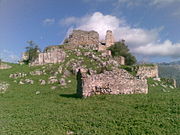
Castle of Aznalmara
Historic site in Ubrique, Spain