Sea Bright–Monmouth Beach Seawall
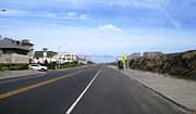
Seawall in New JerseyThe Sea Bright–Monmouth Beach Seawall is a seawall located along the Jersey Shore in the Monmouth County, New Jersey towns of Sea Bright and Monmouth Beach. It roughly runs north-south direction along 4.7 miles (7.6 km) of the barrier spit of land along the lower Sandy Hook peninsula between the Atlantic Ocean and the Shrewsbury River estuary. The use of seawalls, groins, jetties, bulkheads, revetment, and beach nourishment since the late 1800s has made the stretch of coast one of the most heavily engineered sections of ocean shorefront in the world.
Read article


Top Questions
AI generatedMore questions
Nearby Places

Rumson, New Jersey
Borough in Monmouth County, New Jersey, US

Sea Bright, New Jersey
Borough in Monmouth County, New Jersey, US
Rumson-Fair Haven Regional High School
High school in Monmouth County, New Jersey, US

Seabright Lawn Tennis and Cricket Club
United States historic place

St. George's-by-the-River Episcopal Church
Historic church in New Jersey, United States
Galilee, New Jersey
Populated place in Monmouth County, New Jersey, US
Normandie, New Jersey
Populated place in Monmouth County, New Jersey, US
Rumson–Sea Bright Bridge
Lifting road bridge in New Jersey, US