Map Graph

Santa Cruz Department

Department of Bolivia

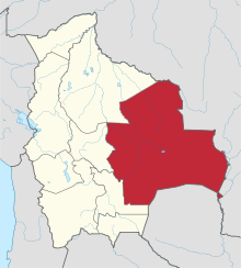
Santa Cruz is the largest of the nine constituent departments of Bolivia, occupying about one-third (33.74%) of the country's territory. With an area of 370,621 km2 (143,098 sq mi), it is slightly smaller than Japan or the US state of Montana. It is located in the eastern part of the country, sharing borders in the north and east with Brazil and with Paraguay in the south.

Read article
File:El_Río_Grande_visto_desde_la_población_de_la_Abra_del_Picacho_(Santa_Cruz,_Bolivia).jpgFile:Flag_of_Santa_Cruz.svgFile:Escudo_de_Santa_Cruz_de_la_Sierra.svgFile:Santa_Cruz_in_Bolivia.svgFile:LandSat-Chiquitos,_Santa_Cruz,_Bolivia_1984.jpgFile:LandSat-Chiquitos,_Santa_Cruz,_Bolivia_2000.jpgFile:Forest,_Santa_Criz_Dept,_Bolivia.jpgFile:Laguna_Uberaba_División_Bolivia_Brasil_Satellite_map.pngFile:Laguna_Concepción_Bolivia_Satellite_map_61.36363W_17.pngFile:Bolivia_department_of_SantaCruz.pngFile:20090221175641!San_Rafael_church_altar_adjusted.jpgFile:Cataratas_Arcoiris_Bolivia.png
Top Questions
AI generated

List the top facts about Santa Cruz Department

Summarize this article

What is the single most intriguing fact about Santa Cruz Department?

Are there any controversies surrounding Santa Cruz Department?

More questions