Pennines
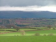
Range of uplands in Northern EnglandThe Pennines, also known as the Pennine Chain or Pennine Hills, are a range of uplands mainly located in Northern England. Commonly described as the "backbone of England" because of its length and position, the range runs from Derbyshire and Staffordshire in the north of the Midlands to Northumberland in North East England. From the Tyne Gap in the north, the range extends south through the North Pennines, Yorkshire Dales, South Pennines, and Peak District to end near the valley of the River Trent. The Border Moors and Cheviot Hills, which lie beyond the Tyne Gap, are included in some definitions of the range.
Read article


Top Questions
AI generatedMore questions
Nearby Places
Cross Fell
Mountain in Cumbria, England

Milburn, Cumbria
Village and civil parish in Cumbria, England

Skirwith
Village in Cumbria, England

Blencarn
Village in Cumbria, England
Ousby
Village in Cumbria, England

Moorhouse and Cross Fell

Kirkland, Culgaith
Village in Cumbria, England

Knock Fell
Hill in Cumbria, England