Peaslake
Village in Surrey, EnglandPeaslake, Hoe, and Colman's Hill are in the centre of the Surrey Hills National Landscape and mid-west of the Greensand Ridge about 5 miles (8.0 km) ESE of Guildford. Surrounded by denser pine and other coniferous forest-clad hills, the three conjoined settlements have a small core in Peaslake itself with the amenities of a village, but are otherwise lightly scattered settlements at a higher elevation than the centre of Shere, the civil parish.
Read article


Top Questions
AI generatedMore questions
Nearby Places

Holmbury St Mary
Village and parish in Surrey, England
Winterfold Forest
Woodland in Surrey, England

Hurt Wood Mill, Ewhurst
Tower mill at Ewhurst, Surrey, England

Oxmoor Copse

Hurtwood House
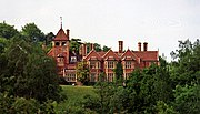
School in Dorking, Surrey, England
Holmbury Hill
Woodland in Surrey, England
Woodhouse Copse, Holmbury St Mary
Duke of Kent School
Independent school in Ewhurst, Surrey, England