Needle Rock Natural Area
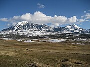
Mountain in United States of AmericaNeedle Rock Natural Area is located at the western edge of the West Elk Mountains of Colorado. The surrounding terrain is characterized by laccolithic mountains flanked by precipitous cliffs, extensive talus aprons, forested mesas, canyons, and spacious, well-watered intermontane basins. Needle Rock is an intrusive plug of monzonite porphyry cropping out 3.5 miles (5.6 km) east-northeast of the Town of Crawford in Delta County, Colorado, United States. With an elevation of 7,797 feet (2,377 m), the towering rock spire stands 800 feet (240 m) tall above the floor of the Smith Fork of the Gunnison River valley. The massive rock feature originated in the Oligocene geological epoch when magma intruded between existing sedimentary rocks as the crown of a buried laccolith or possibly the underlying conduit of a laccolith. Subsequent erosion has exposed the prominent rock formation seen in the natural area today.
Read article


Top Questions
AI generatedMore questions
Nearby Places

Crawford, Colorado
Town in Colorado, United States
Mount Lamborn
Mountain in Colorado, United States

Maher, Colorado
Unincorporated community in Colorado, United States

Crawford State Park (Colorado)
State park in Colorado

Crawford Dam
Dam in Delta County, Colorado, United States

Saddle Mountain (Delta County, Colorado)
Mountain in Colorado, USA

Landsend Peak
Mountain in Colorado, US
Youngs Peak
Mountain in Colorado, USA