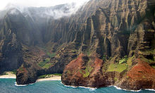
Nā Pali Coast State Park
State park in Hawaii, United StatesNā Pali Coast State Park is a 6,175-acre (2,499 ha) state park in the U.S. state of Hawaii, located in the center of the rugged 16-mile (26 km) northwest side of Kauaʻi, the second-oldest inhabited Hawaiian island. The Nā Pali coast itself extends southwest from Keʻe Beach all the way to Polihale State Park. The nā pali along the shoreline rise as much as 4,000 feet (1,200 m) above the Pacific Ocean. The state park was formed to protect the Kalalau Valley.
Read article
Top Questions
AI generatedMore questions
Nearby Places

Kalalau Trail
Trail along Nā Pali Coast of the island of Kauai in the state of Hawaii, U.S.

Kalalau Valley
Valley in Hawaii, United States

Kalalau Beach
Beach on the Nā Pali Coast in north-west Kauaʻi in Hawaiʻi, U.S.

Honopū Valley

Hanakoa Valley
Valley in Hawaii, United States

Civilian Conservation Corps Camp in Kokeʻe State Park
United States historic place

Hanakapiai Falls
Keanapuka Mountain
Mountain on Kauai in Hawaii, United States of America


