Mt. Pisgah State Park
1,302-acre Pennsylvania state parkMt. Pisgah State Park is a 1,302-acre (527 ha) Pennsylvania state park in Smithfield, Springfield, Troy and West Burlington Townships, Bradford County, Pennsylvania in the United States. The park is located almost exactly halfway between Troy and Towanda, along Pennsylvania State Route 3019, near U.S. Route 6, at the base of Mt. Pisgah. The park is bordered by Mill Creek, Mt. Pisgah County Park and State Game Land 289. Mill Creek which flows through the park has been dammed and forms Stephen Foster Lake a 75-acre (30 ha) man-made lake.
Read article
.jpg)


Top Questions
AI generatedMore questions
Nearby Places

Burlington, Pennsylvania
Borough in Pennsylvania, United States

Smithfield Township, Bradford County, Pennsylvania
Township in Pennsylvania, United States

West Burlington Township, Pennsylvania
Township in Pennsylvania, United States
Mount Pisgah (Bradford County, Pennsylvania)
Mountain in Pennsylvania, United States

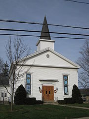
Methodist Episcopal Church of Burlington
Historic church in Pennsylvania, United States

Mauch Chunk Mountain
East Troy, Pennsylvania
Unincorporated community in Pennsylvania, United States
East Smithfield, Pennsylvania
Unincorporated community in Pennsylvania, United States