Map Graph

Mount Roraima

Mountain in Brazil, Guyana and Venezuela

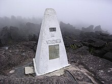
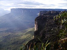
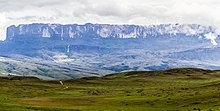
Mount Roraima is the highest of the Pacaraima chain of tepuis or plateaux in South America. It is located at the junction of Brazil, Guyana and Venezuela. A characteristic large flat-topped mountain surrounded by cliffs 400–1,000 m (1,300–3,300 ft) high. The highest point of Mount Roraima is located on the southern edge of the cliff at an elevation of 2,810 m (9,220 ft) in Venezuela, and another protrusion at an elevation of 2,772 m (9,094 ft) at the junction of the three countries in the north of the plateau is the highest point in Guyana. The name Mount Roraima came from the native Pemon people. Roroi in the Pemon language means "blue-green", and ma means "great".

Read article
File:Roraima3_(79).JPGFile:South_America_laea_relief_location_map.jpgFile:Relief_Map_of_Brazil.jpgFile:Guyana_physical_map.svgFile:Venezuela_relief_location_map_(+claimed).svgFile:Abismo_com_fim.jpgFile:Triple_Point,_Mount_Roraima.jpgFile:Mount_Roraima,_Venezuela_(12371474504).jpgFile:Panorámica_del_Tepuy_Roraima.jpgFile:Schomburgk_Twelve_Views_Roraima.jpgFile:BritGY_p149_-_RORAIMA.jpg
Top Questions
AI generated

List the top facts about Mount Roraima

Summarize this article

What is the single most intriguing fact about Mount Roraima?

Are there any controversies surrounding Mount Roraima?

More questions
Timeline
AI Generated
  • 1595European discovery of Mount Roraima during a Spanish and British race to colonize this part of South America.
  • 1838The first expedition to Mount Roraima took place when German scientist and explorer Robert Hermann Schomburgk observed it during a Royal Geographical Society-funded expedition.
  • 1840The British government commissioned Robert Hermann Schomburgk to establish the boundaries between British Guiana and Venezuela.
Show full timeline