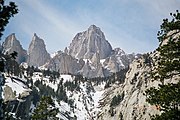
Mount Hale (California)
Mountain in the state of CaliforniaMount Hale is a 13,494-foot-elevation (4,113-meter) mountain summit located west of the crest of the Sierra Nevada mountain range in Tulare County, California. It is situated in Sequoia National Park, 1.4 mile northwest of Mount Whitney, one mile northeast of Mount Young, and 0.85 mile west-southwest of Mount Randy Morgenson, the nearest higher neighbor. The John Muir Trail traverses below the south aspect of the mountain, providing approach access. Mt. Hale ranks as the 63rd-highest summit in California. Topographic relief is significant as the north aspect rises 1,770 feet above Wales Lake in approximately one-quarter mile.
Read article
Top Questions
AI generatedMore questions
Nearby Places

Mount Whitney
Highest mountain in the contiguous United States

List of California 14,000-foot summits

Whitney Classic
Mountain bike race

List of mountain peaks of California

List of mountain ranges of California

Smithsonian Institution Shelter
United States historic place

Mount Young (California)
Mountain in the state of California

Mount Randy Morgenson
Mountain in the state of California


