Map Graph

Mount Fuji

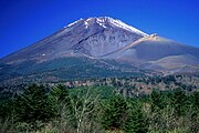
Volcano in Yamanashi and Shizuoka Prefectures, Japan

Mount Fuji is an active stratovolcano located on the Japanese island of Honshu, with a summit elevation of 3,776.24 m. It is the tallest mountain in Japan, the second-highest volcano located on an island in Asia, and seventh-highest peak of an island on Earth. Mount Fuji last erupted from 1707 to 1708. The mountain is located about 100 km (62 mi) southwest of Tokyo and is visible from the Japanese capital on clear days. Mount Fuji's exceptionally symmetrical cone, which is covered in snow for about five months of the year, is commonly used as a cultural icon of Japan and is frequently depicted in art and photography, as well as visited by sightseers, hikers and mountain climbers.

Read article
File:Views_of_Mount_Fuji_from_Ōwakudani_20211202.jpgFile:Japan_natural_location_map_with_side_map_of_the_Ryukyu_Islands.jpgFile:Shizuoka_géolocalisation_relief.svgFile:Aerial_panorama_of_Mount_Fuji_from_Lake_Saiko._June_2023.jpgFile:Aerial_panorama_of_Mount_Fuji_with_Saiko_Iyashi-no-Sato_Nenba_in_the_foreground._June_2023.jpgFile:「富嶽三十六景_凱風快晴」-South_Wind,_Clear_Sky_(Gaifū_kaisei),_also_known_as_Red_Fuji,_from_the_series_Thirty-six_Views_of_Mount_Fuji_(Fugaku_sanjūrokkei)_MET_DP141062.jpgFile:Mount_Fuji_from_Omiya_by_Kusakabe_Kimbei_c1890.pngFile:Mt_Fuji_NASA_ISS002-E-6971_large.jpgFile:Mount_Fuji_Relief_Map,_SRTM-1.jpgFile:Fuji_3D.gifFile:Geologycal_cross-section_of_Fuji.pngFile:Hasshinpo_of_Mt.Fuji_40.jpgFile:Mount_Ashiwada_and_Mount_Fuji.jpgFile:Fuji_in_the_Mountains_of_Taisekiji_LACMA_M.2006.136.141a-b.jpgFile:Mt.Fuji_Shizuoka_Airport.jpgFile:Fuji_illustration.jpegFile:Torii_near_the_summit_of_mount_Fuji_2015.jpgFile:Mt_Fuji_Summit.jpgFile:Outer_shrine_of_Fujisan_Hongu_SengenTaisha_(富士山本宮浅間大社)_-_panoramio.jpg
Top Questions
AI generated

List the top facts about Mount Fuji

Summarize this article

What is the single most intriguing fact about Mount Fuji?

Are there any controversies surrounding Mount Fuji?

More questions