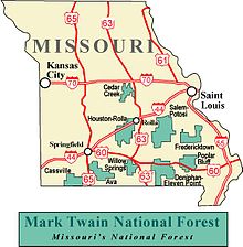
Mark Twain National Forest
United States historic centerMark Twain National Forest (MTNF) is a U.S. National Forest located in the southern half of Missouri, composed of nine disconnected parcels. MTNF was established on September 11, 1939. It is named for author Mark Twain, a Missouri native. The MTNF covers 3,068,800 acres (12,419 km2) of which 1,506,100 acres (6,095 km2) is public owned, 78,000 acres (320 km2) of which are Wilderness, and National Scenic River area. MTNF spans 29 counties and represents 11% of all forested land in Missouri. MTNF's nine tracts are divided into six distinct ranger districts: Ava-Cassville-Willow Springs, Eleven Point, Houston-Rolla, Cedar Creek, Poplar Bluff, Potosi-Fredericktown, and the Salem. Its headquarters are in Rolla, Missouri.
Read article
Top Questions
AI generatedMore questions
Nearby Places
Bixby, Missouri
Unincorporated community in the U.S. state of Missouri

Goodland, Iron County, Missouri
Unincorporated community in the American state of Missouri
Brooks Creek (Missouri)
Stream in the American state of Missouri
Buick, Missouri
Former community in Missouri, United States
Henderson Creek (Neals Creek tributary)
Stream in the U.S. state of Missouri
Hoover Hollow
Neals Creek
Stream in the US state of Missouri
Dent Township, Iron County, Missouri
Township in Iron County, Missouri, U.S.


