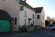
Luccombe, Somerset
Human settlement in EnglandLuccombe or Luckham is a village and civil parish in the Exmoor National Park in the English county of Somerset. It at the foot of the moor's highest hill, the 1,750 feet (533 m) Dunkery Beacon, and is about one mile south of the A39 road between Porlock and Minehead. Administratively it forms part of the district of Somerset West and Taunton. The parish includes the hamlets of Stoke Pero and Horner, as well as the former hamlet of Wilmersham.
Read article
Top Questions
AI generatedMore questions
Nearby Places

Holnicote Estate
Country estate in Somerset, England

Coleridge Way
Long-distance footpath in Somerset and Devon, England

Selworthy
Village in Somerset, England

Bury Castle, Selworthy
Iron Age hillfort in Somerset, England

West Somerset Rural Life Museum and Victorian School
Small museum in England

Hawkcombe Woods
Nature reserve in Somerset, England

Dovecot at Blackford Farm
Grade II* listed building

Chapel of St Leonard, Tivington
Church in Somerset, England

