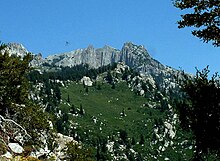
Lone Peak (Utah)
Mountain in the U.S. state of UtahLone Peak is a mountain summit in the Wasatch Range southeast of Salt Lake City, Utah, United States, and the center of the Lone Peak Wilderness, established in 1978. With an elevation of 11,260 feet (3,430 m), it is one of the highest peaks in the range and among the most prominent of the Wasatch Front, towering over the Salt Lake City suburb of Draper and easily visible from most of the valley, which makes it a popular destination for hiking and rock climbing.
Read article
Top Questions
AI generatedMore questions
Nearby Places

Wasatch Range
Sub-range of the Rocky Mountains in the western United States

Little Cottonwood Canyon
Canyon in Northern Utah

Pfeifferhorn
Mountain in the American state of Utah

Lone Peak Wilderness
Wilderness area in Utah and Salt Lake counties in Utah, United States
Granite Mountain (Salt Lake County, Utah)
Underground document storage facility in Utah, United States
James A. and Janet Muir House
United States historic place

Box Elder Peak (Utah County, Utah)
Mountain in Utah, United States
Dry Creek (Utah)
River in Utah, United States


