Lolo Pass (Oregon)
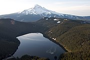
Mountain pass in Oregon, United StatesLolo Pass is a mountain pass 6 miles (10 km) northwest of Mount Hood and 10 miles (16 km) northeast of Zigzag, Oregon, on the Clackamas–Hood River county line. It divides the Sandy River watershed on the southwest from the Hood River watershed on the northeast.
Read article
|File:Lolo_pass_medium_with_mount_hood_background_P3125.jpeg)
|File:Lolo_pass_from_2_km_south_on_road_P3126.jpeg)
Top Questions
AI generatedMore questions
Nearby Places

Mount Hood Wilderness
Protected area

Timberline Trail
Hiking trail in Oregon, USA
Bull Run Lake
Reservoir in Oregon, US

Ramona Falls (Oregon)
Waterfall in Oregon, United States

Upper Sandy Guard Station Cabin
United States historic place
Muddy Fork (Oregon)
River in Oregon, United States
Clear Fork (Oregon)
River in Oregon, United States
Glisan Glacier
Glacier located on Mount Hood, Oregon, United States