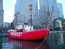
Lightship Nantucket
Lightship station on the Nantucket Shoals south of Nantucket Island, United StatesThe station named Nantucket or Nantucket Shoals was served by a number of lightvessels that marked the hazardous Nantucket Shoals south of Nantucket Island. The vessels, given numbers as their "name," had the station name painted on their hulls when assigned to the station. Several ships have been assigned to the Nantucket Shoals lightship station and have been called Nantucket. It was common for a lightship to be reassigned and then have the new station name painted on the hull. The Nantucket station was a significant US lightship station for transatlantic voyages. Established in 1854, the station marked the limits of the dangerous Nantucket Shoals. She was the last lightship seen by vessels departing the United States, as well as the first beacon seen on approach. The position was 40 miles (64 km) southeast of Nantucket Island, the farthest lightship in North America, and experienced clockwise rotary tidal currents.


