Map Graph

Kythnos

Municipality in Greece

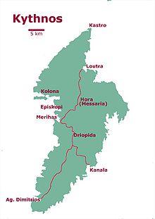
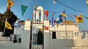
Kythnos, commonly called Thermia, is a Greek island and municipality in the Western Cyclades between Kea and Serifos. It is 56 nautical miles (104 km) from the Athenian harbor of Piraeus. The municipality Kythnos is 100.187 km2 (38.68 sq mi) in area and has a coastline of about 100 km (62 mi). Mount Kakovolo is island's highest peak (365m).

Read article
File:Chora_of_Kythnos,_Cyclades,_190176.jpgFile:Greece_location_map.svgFile:2011_Dimos_Kythnou.pngFile:Kythnos-map.jpgFile:Vryokastro_archaeological_site_(centre_of_site).JPGFile:Dryopida.jpgFile:Κάστρο_Ωριάς_1.jpgFile:Kythnos02.JPGFile:Θερμιώτικος_Μπάλλος.jpgFile:Kythnos,-stone-walls.jpgFile:Kolona_beach,_Kythnos_2009_n01.jpgFile:Kythnos03.JPGFile:Driopis-street.jpgFile:Δρυοπίδα_Kythnos.jpgFile:Katafiki_corridors.jpgFile:Χώρα_Κύθνου_από_μονοπάτι_για_Παναγία_του_Νίκους.jpgFile:Αγ._Παντελεήμων_Χώρα_Κύθνου.jpgFile:Aghios_Savvas.jpgFile:Colorful_porch.jpgFile:Γεωργία_Κύθνος.jpgFile:Loutra,_Kythnos,_190200.jpgFile:Kanala,_Kythnos,_190421.jpgFile:Traditional_old_mill.jpg
Top Questions
AI generated

List the top facts about Kythnos

Summarize this article

What is the single most intriguing fact about Kythnos?

Are there any controversies surrounding Kythnos?

More questions