Kurnool district
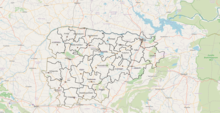
District of Andhra Pradesh, IndiaKurnool district is one of the eight districts in the Rayalaseema region of the Indian state of Andhra Pradesh after the districts are reorganised in April 2022. It is located in the north western part of the state and is bounded by Nandyal district in the east, Anantapur district in the south, Raichur district of Karnataka in the northwest, Bellary district of Karnataka in the west, and Jogulamba Gadwal district of Telangana in the north. It has a population of 2,271,686 based on the 2011 census. The city of Kurnool is the headquarters of the district.
Read article
Top Questions
AI generatedMore questions
Nearby Places

Kurnool
City in Andhra Pradesh, India

Kurnool Medical College
College in Andhra Pradesh, India
Kurnool Lok Sabha constituency
Constituency of the Indian parliament in Andhra Pradesh
Kallur, Kurnool district
Municipal Corporation in Andhra Pradesh, India

Kurnool Assembly constituency
Constituency of the Andhra Pradesh Legislative Assembly, India
Osmania College, Kurnool
Kurnool bus station
Bus station
Kurnool mandal
Mandal in Andhra Pradesh, India


