Kneeton
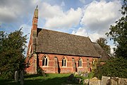
Hamlet and civil parish in Nottinghamshire, EnglandKneeton is a hamlet and civil parish in the county of Nottinghamshire, England. The population as of the 2011 census remained less than 100 so was included in the civil parish count for Screveton, it was however reported as 47 residents at the 2021 census. The village lies on the A46 road between Nottingham and Newark and is on the escarpment of the Trent Hills that sit above the flood plain of the River Trent. RAF Syerston is nearby. There is a railway station at Lowdham. The church is 14th century Grade II listed, and dedicated to St. Helen. A mid-18th century Grade II listed barn survives at Hall Farm, Kneeton.
Read article


Top Questions
AI generatedMore questions
Nearby Places

Car Colston
English Midland village in Nottinghamshire, England
Hoveringham
Village and civil parish in Nottinghamshire, England

1958 Syerston Avro Vulcan crash
1958 aviation accident
St Michael's Church, Hoveringham
Church in Hoveringham, England

St Helen's Church, Kneeton
Church in Kneeton, England
St Mary's Church, Car Colston
Church in Car Colston, England

St Wilfrid's Church, Screveton
Church in Screveton, England

Screveton
Village in Nottinghamshire