Knaptoft
Human settlement in EnglandKnaptoft is a deserted medieval village and civil parish in the Harborough district of Leicestershire and lies approximately 9.7 miles (15.6 km) south of the city of Leicester, England. According to the University of Nottingham English Place-names project, the settlement name Knaptoft could mean "cnafa" for 'a boy, a young man, a servant, a menial, or a personal name' and 'toft', the plot of ground in which a dwelling stands. The population of the civil parish at the 2011 census was 47.
Read article


Top Questions
AI generatedMore questions
Nearby Places

Mowsley
Human settlement in England

Shearsby
Human settlement in England

Arnesby
Village in Leicestershire, England

Bruntingthorpe
Human settlement in England

Saddington
Human settlement in England

Laughton, Leicestershire
Human settlement in England
St Peter's Church, Arnesby
Church in Arnesby, Leicestershire
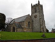
St Mary's Church, Bruntingthorpe
Church in Bruntingthorpe, Leicestershire