Kintampo waterfalls
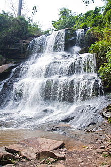
Waterfall in Kintampo, GhanaKintampo waterfalls is one of Ghana' highest waterfalls located in Bono East. It was formerly known as Sanders Falls during the colonial days. It is located on the Pumpum river, a tributary of the Black Volta, about 4 kilometres (2.5 mi) north of the Kintampo municipality, on the Kumasi–Tamale road. It is just after the Falls Rest Stop when moving Northwards, on the right side of the road. This waterfall is hidden in the forest and formed by three main drops, with the longest measuring 25 metres (82 ft), followed by a number of steps and cascades, and the river, which falls about 70 metres (230 ft).
Read article
Top Questions
AI generatedMore questions


