Map Graph

Kerama Islands

Island group within Ryukyu Islands

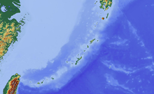
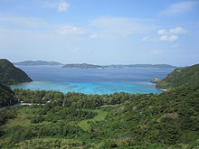
The Kerama Islands are a subtropical island group 32 kilometres (20 mi) southwest of Okinawa Island in Japan.

Read article
File:Okinawa_kerama_islands.jpgFile:Kerama_Islands_Map_Okinawa.pngFile:Okinawa_géolocalisation_relief.svgFile:Location_map_Ryukyu_Islands.pngFile:Japan_natural_location_map_with_side_map_of_the_Ryukyu_Islands.jpgFile:Zamami_aerial.jpgFile:Aka_Island_gsi-20081121.jpgFile:Maeshima_Okinawa_ISS045.jpgFile:Kubashima_20081121-gsi.jpgFile:Yakabi_Island.jpgFile:Geruma_Island_20081121-gsi.jpgFile:Fukaji_Island_20081121-gsi.jpgFile:Amuro_Island.jpgFile:Gishippu_Island.jpgFile:Kuro_Island,_Tokashiki.jpgFile:Ou-jima,_Zamami.jpgFile:Ama_beach_in_Zamami_Island.jpgFile:Aharen_Beach_On_Tokashiki_Island_2009_(7373).JPGFile:Tokashiku_Beach_On_Tokashiki_Island_2009_(7372).JPGFile:Tokashiku_Beach_on_Tokashiki_Island_Okinawa_2018.pngFile:Coral_reef_life_near_Akajima_07.jpgFile:Coral_reef_life_near_Akajima_16.jpgFile:Coral_reef_life_near_Akajima_13.jpgFile:Landings_in_the_Keramas.jpg
Top Questions
AI generated

List the top facts about Kerama Islands

Summarize this article

What is the single most intriguing fact about Kerama Islands?

Are there any controversies surrounding Kerama Islands?

More questions