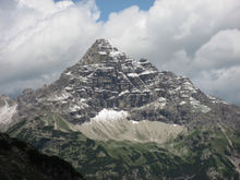
Hochvogel
Mountain on the border between Germany and AustriaThe Hochvogel is a 2,592-metre-high (8,504 ft) mountain in the Allgäu Alps. The national border between Germany and Austria runs over the summit. Although only the thirteenth highest summit in the Allgäu Alps, the Hochvogel dominates other parts of Allgäu Alps and the other ranges in the immediate neighbourhood. This is because the majority of the higher peaks are concentrated in the central and western part of the Allgäu Alps. The Hochvogel stands on its own in the eastern part of the mountain group; the nearest neighbouring summits are 200 to 300 metres lower. Experienced climbers can ascend the summit on two marked routes.
Read article
Top Questions
AI generatedMore questions


