Map Graph

Herm

Island in the Bailiwick of Guernsey in the Channel Islands

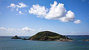
Herm is one of the Channel Islands and part of the Parish of St Peter Port in the Bailiwick of Guernsey. It is located in the English Channel, north-west of France and south of England. It is 2,183 m (7,162 ft) long and under 873 metres (2,864 ft) wide; oriented north–south, with several stretches of sand along its northern coast. The much larger island of Guernsey lies to the west, Jersey lies to the south-east, and the smaller island of Jethou is just off the south-west coast.

Read article
File:Flag_of_Herm.svgFile:Blason_Ile_Herm.svgFile:Guernsey-Herm.pngFile:Hermdunord.jpgFile:Roberts_Cross_Herm.jpgFile:White_House_Hotel,_Herm_1968_-_geograph.org.uk_-_85.jpgFile:Herm,_Sark_and_Jethou.jpgFile:HermShellBeach.JPGFile:Caquorobert.jpgFile:Herm_Harbour_in_1968_-_geograph.ci_-_77.jpgFile:Haven_van_Herm_bij_eb.JPGFile:St_Tugual's_Chapel_op_Herm.jpgFile:Herm_Obelisk.jpgFile:Antony_Gormley's_"Another_Time_XI"_on_Herm_-_facing_right.JPGFile:Ferry_approaching_the_Rosaire_Landing,_Herm_-_geograph.org.uk_-_87.jpg
Top Questions
AI generated

List the top facts about Herm

Summarize this article

What is the single most intriguing fact about Herm?

Are there any controversies surrounding Herm?

More questions