Hartley, Cumbria
Village and civil parish in Cumbria, EnglandHartley is a village and civil parish in the Westmorland and Furness district of Cumbria, England. It is about 0.5 miles (0.8 km) east of Kirkby Stephen. The area has many old lead and copper mines that are now abandoned as well as a large quantity of iron haematite, ironstone and ore. At the highest peak in Hartley stand nine obelisks referred to as "Nine Standards". Nobody knows the true purpose of the "Nine Standards" although some believe that they were used to create a sense of a forthcoming army to scare the enemy forces. However, it is more widely believed that they were placed as geographical aid to help outline the borders between the two neighbouring counties, Westmorland and Yorkshire. Hartley is also home to Hartley Castle. It was originally built as a "tower house circa 1353 and extended circa 1600" and then re- developed in the 18th century. The castle was built at the southern point of Hartley.
Read article


Top Questions
AI generatedMore questions
Nearby Places
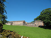
Hartley Castle

Devil's Grinding Mill

Kirkby Stephen
Market town in Cumbria, England
Kirkby Stephen East railway station
Disused railway station in Cumbria, England
Stainmore Railway Company
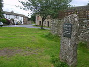
Winton, Cumbria
Village and civil parish in Cumbria, England

Kirkby Stephen Parish Church
Church in Kirkby Stephen, England
Kirkby Stephen Grammar School
Comprehensive school in Cumbria, England