Hainich
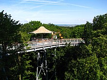
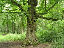
Hill chain in GermanyHainich is a forested hill chain in the state of Thuringia in Germany, between the towns of Eisenach, Mühlhausen and Bad Langensalza. Hainich covers an area of around 160 km², of which, since 31 December 1997, half has been designated as Hainich National Park. The highest point in Hainich is Alte Berg at 1621 ft. The Mühlhäuser Stadtwald in the northern part of Hainich is the largest municipal forest in Thuringia. The landmark of Hainich is Betteleiche, a 600-year-old common oak at Ihlefeld.
Read article
Top Questions
AI generatedMore questions
Nearby Places

Nazza
Municipality in Thuringia, Germany
Mihla
Ortsteil of Amt Creuzburg in Thuringia, Germany

Lauterbach, Thuringia
Municipality in Thuringia, Germany

Kammerforst
Municipality in Thuringia, Germany
Hainich-Werratal

Hainich National Park
National Park in Thuringia, Germany

Lauterbach (Werra)
River in Thuringia, Germany

Lempertsbach
River in Thuringia, Germany


