Gwithian
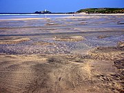
Human settlement in EnglandGwithian is a coastal village and former civil parish, now in the parish of Gwinear-Gwithian, in the Cornwall district, in west Cornwall, England. It is three miles (5 km) north-east of Hayle and four miles (6.5 km) east of St Ives, Cornwall across St Ives Bay. In 1931 the parish had a population of 634. On 1 April 1934 the parish was abolished to form "Gwinear Gwithian".
Read article
Top Questions
AI generatedMore questions
Nearby Places

Godrevy
Area on the eastern side of St Ives Bay, west Cornwall, England

Gwinear–Gwithian
Coastal civil parish in west Cornwall, England

Connor Downs
Village in west Cornwall, England

The Towans

Red River (Koner)
River in north-west Cornwall, England

Nancemellin
Hamlet in Cornwall, England
St Gothian Sands

St Gothian's Church, Gwithian
Church in Cornwall, England


