Gunt
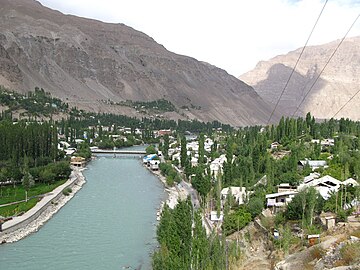
River in TajikistanThe Gunt is a river in the south of Tajikistan, north of the Shughnon Range. It is 296 kilometres (184 mi) long and has a basin area of 13,700 square kilometres (5,300 sq mi). Its source, Lake Yashilkul, is situated at the edge of the Alichur Pamir, a high plateau or pamir at an elevation of 3,720 m. The city of Khorog is located at the confluence of the Gunt with the Panj. See Gorno-Badakhshan Autonomous Region for surrounding area.
Read article
Top Questions
AI generatedMore questions
Nearby Places

Khorog
Capital of Gorno-Badakhshan, Tajikistan
Aga Khan Lycée, Khorog
Private school
Khorugh State University
Ghar Javin
Place in Badakhshan, Afghanistan
Shiveh
Place in Badakhshan Province, Afghanistan

Tajik–Afghan bridge at Tem-Demogan
Bridge in Shughnan, Tajikistan

1993 Tajikistan Airlines Yakovlev Yak-40 crash
1993 aviation accident in Tajikistan

Shakhdara River
River in Tajikistan
