Greer, Arizona
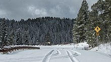
CDP in Apache County, ArizonaGreer is an unincorporated community and census-designated place in Apache County, Arizona, United States. Located within the White Mountains of Arizona and surrounded by the Apache-Sitgreaves National Forest, Greer is the highest town in the state at an elevation of approximately 8,400 feet. As of the 2020 census it had a population of 58. Greer was founded circa 1879 by Mormon settlers from Utah. The Greer post office has the ZIP code of 85927.
Read article
Top Questions
AI generatedMore questions
Nearby Places
Bunch Reservoir
Lakes on the Little Colorado River in Apache County, Arizona
River Reservoir
Waterbody in Apache County, Arizona
Tunnel Reservoir
Waterbody in Apache County, Arizona
Lee Valley Lake
Lake in Apache County, Arizona, US
White Mountain Grasslands Wildlife Area
Protected area in Apache County, Arizona, US

Butterfly Lodge
United States historic place
Benny Creek
Waterway in Apache County, Arizona
Butler Canyon
Landform in Apache County, Arizona


