Geography of Saint Vincent and the Grenadines
Saint Vincent and the Grenadines is an island state in the Windward Islands of the Lesser Antilles, an island arc of the Caribbean Sea in North America. The country consists of the main island of Saint Vincent and the northern two-thirds of the Grenadines, a chain of small islands stretching south from Saint Vincent to Grenada. Its total land area is 390 km2 of which 342.7 km2 is the main island of Saint Vincent. The country's capital is at Kingstown on Saint Vincent.
Read article

Top Questions
AI generatedMore questions
Nearby Places

Kingstown
Capital and chief port of Saint Vincent and the Grenadines
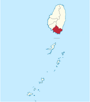
Saint George Parish, Saint Vincent and the Grenadines
Parish in Kingstown, Saint Vincent and the Grenadines

Roman Catholic Diocese of Kingstown
Latin Catholic jurisdiction in the Caribbean

Saint Vincent and the Grenadines Botanic Gardens
Questelles
Place in Saint Vincent, Saint Vincent and the Grenadines
Victoria Park (Kingstown)

St. Vincent Girls' High School
Public secondary school in Saint Vincent and the Grenadines
Assumption Cathedral, Kingstown
Cathedral of the Catholic Diocese of Kingstown