Map Graph

Geography of Mexico

The geography of Mexico describes the geographic features of Mexico, a country in the Americas. Mexico is located at about 23° N and 102° W in the southern portion of North America. From its farthest land points, Mexico is a little over 3,200 km (2,000 mi) in length. Mexico is bounded to the north by the United States, to the west and south by the Pacific Ocean, to the east by the Gulf of Mexico, and to the southeast by Belize, Guatemala, and the Caribbean Sea. The northernmost constituent of Latin America, it is the most populous Spanish-speaking country in the world. Mexico is the world's 13th largest country, three times the size of Texas.

Read article
File:Mexico_topographic_map-blank.svgFile:Mexico_tectonic_plates.pngFile:MountainIztaccihuatlMexico01.jpgFile:Pico_de_Orizaba_desde_Hidalgo,_Puebla.jpgFile:Mexico_watersheds.jpgFile:Lago_de_Chapala.jpgFile:Map_of_earthquakes_in_Mexico.svgFile:Baja_California_Desert.jpgFile:Mexico_Köppen.svgFile:Pachycereus_pringlei_forest.jpgFile:Yucca_decipiens_3.jpgFile:Selva_Lacandona.JPGFile:Rio_Grande_in_Big_Bend_NP.jpgFile:SierraGordaQueretaro.JPGFile:03_Tour_Cañon_(122).JPGFile:Pantanos_de_Centla_2.JPGFile:Field_near_San_Miguel_de_Allende.jpgFile:Map_mexico_volcanoes.gif
Top Questions
AI generated

List the top facts about Geography of Mexico

Summarize this article

What is the single most intriguing fact about Geography of Mexico?

Are there any controversies surrounding Geography of Mexico?

More questions
Timeline
AI Generated
  • 1940Tropical forests covered almost half of the state of Tabasco.
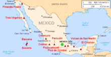
  • 1943Parícutin in northwest Mexico began as puffs of smoke in a cornfield.
  • 1953A decade later, Parícutin volcano was 424 meters high.
Show full timeline