Geography of Cyprus
Cyprus is an island in the Eastern Basin of the Mediterranean Sea. It is the third-largest island in the Mediterranean, after the Italian islands of Sicily and Sardinia, and the 80th-largest island in the world by area. It is located south of the Anatolian Peninsula, yet it belongs to the Cyprus Arc. Geographically, Cyprus is located in West Asia, but the country is considered a European country in political geography. Cyprus also had lengthy periods of mainly Greek and intermittent Anatolian, Levantine, Byzantine, Turkish, and Western European influence.
Read article

.svg)

.jpg)


Top Questions
AI generatedMore questions
Nearby Places

Cyprus
Mediterranean island country in the Middle East

Agia Eirini, Nicosia
Village in Nicosia District, Cyprus
Saranti
Village in Nicosia District, Cyprus
Spilia, Cyprus
Village in Nicosia District, Cyprus
Kannavia
Village in Nicosia District, Cyprus

Lagoudera
Village in Nicosia District, Cyprus
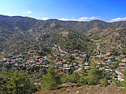
Xyliatos
Village in Nicosia District, Cyprus
Panagia tou Araka
Byzantine church in Cyprus