Geography of Austria
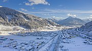
Austria is a predominantly mountainous country in Central Europe, approximately between Germany, Italy and Hungary. It has a total area of 83,871 square kilometres (32,383 sq mi).
Read article


Top Questions
AI generatedMore questions
Nearby Places

St. Johann im Pongau District
District in Salzburg, Austria
Rettenstein

Altenmarkt im Pongau
Municipality in Salzburg, Austria

Flachau
Municipality in Salzburg, Austria
Eben im Pongau
Municipality in Salzburg, Austria

Kleinarl
Municipality in Salzburg, Austria

Wagrain
Municipality in Salzburg, Austria
Austria
Country in Central Europe