Map Graph

General Tinio

Municipality in Central Luzon, Philippines

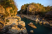
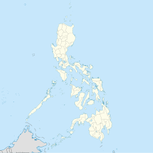
General Tinio, formerly known as Papaya, is a first-class municipality in the province of Nueva Ecija, Philippines with an area of 68,229.29 hectares, the second biggest in the province. It lies at the foot of the Sierra Madre Mountains and encompass parts of its mountain range and rugged foothills. General Tinio is bounded at the north by Sta. Rosa (25 km), Laur and Gabaldon municipalities. In East by Quezon, in South by Gapan (20 km), Nueva Ecija and San Miguel, Bulacan and in West by Penaranda municipality (5.0 km).

Read article
File:Tiniojf.JPGFile:General_Tinio_Nueva_Ecija.pngFile:General_Tinio_in_Nueva_Ecija.svgFile:Philippines_location_map_(square).svgFile:Papaya_appears_in_an_1850_book_in_Madrid.jpgFile:Jose_W._Diokno_and_Ninoy_Aquino_at_the_Aquino-Diokno_Memorial.pngFile:MINALUNGAO_NATIONAL_PARK.jpgFile:Luzon_Negritos_Map_by_Martin_W._Lewis.pngFile:Gapan_Church.jpgFile:The_History_and_Cultural_Life_of_Papaya,_Nueva_Ecija.pngFile:National_Library_-_El_Mapa_Nueva_Ecija_Gobierno_Civil.jpgFile:PH_nhi_epifanio_de_los_santos.jpgFile:Macabebes_against_Tagals_Newspaper_Clipping.pngFile:Rio_Chiquito_in_the_1734_Velarde_Map.pngFile:Topographic_Map_of_General_Tinio_from_DENR.jpegFile:Flood_Map_if_the_flood_reaches_at_40_m_above_sea_level.pngFile:Minalungao_Protected_National_Park.jpgFile:Sabong_Indio_by_Justiniano_Asuncion.jpegFile:Maestro_Pedro_"Bigas"_Manuel_Bautista.pngFile:Tiniojf36788.JPGFile:Tiniojf37.JPGFile:Tiniojf6.JPGFile:Holy_Cross_Parish_Church_in_General_Tinio,_Nueva_Ecija.jpgFile:Public_Market_in_General_Tinio,_Nueva_Ecija.jpgFile:Monumentsjf2.JPGFile:Minalungao_National_Park_Bridge_Shot.jpgFile:Upper_Tabuating_Dam_south_view.jpg
Top Questions
AI generated

List the top facts about General Tinio

Summarize this article

What is the single most intriguing fact about General Tinio?

Are there any controversies surrounding General Tinio?

More questions