Frederica River
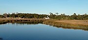
River in Georgia, United StatesThe Frederica River is an 11.0-mile-long (17.7 km) tidal river in Glynn County, Georgia. It forms the western boundary of Saint Simons Island of the Georgia Sea Islands. Fort Frederica National Monument is located on the eastern bank of the river on Saint Simons Island.
Read article


Top Questions
AI generatedMore questions
Nearby Places
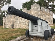
Fort Frederica National Monument
Gascoigne Bluff
United States historic place

Battle of Gully Hole Creek
Battle during the War of Jenkins' Ear
Frederica Academy
Private, college preparatory school in Saint Simons Island, Glynn County, Georgia, United States

Epworth by the Sea
American Christian conference and retreat center
Igbo Landing
Historic site at Dunbar Creek, Georgia
Jewtown, Georgia
Unincorporated community in Georgia, United States

Christ Church (St. Simons, Georgia)
Church in Georgia , United States