Fraser Canyon
Canyon in British Columbia, CanadaThe Fraser Canyon is a major landform of the Fraser River where it descends rapidly through narrow rock gorges in the Coast Mountains en route from the Interior Plateau of British Columbia to the Fraser Valley. Colloquially, the term "Fraser Canyon" is often used to include the Thompson Canyon from Lytton to Ashcroft, since they form the same highway route which most people are familiar with, although it is actually reckoned to begin above Williams Lake at Soda Creek Canyon near the town of the same name.
Read article


.jpg)

Top Questions
AI generatedMore questions
Nearby Places
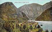
Yale, British Columbia
Town in British Columbia, Canada
Spuzzum
Place in British Columbia, Canada

Alexandra Bridge Provincial Park
Provincial park in British Columbia, Canada
Alexandra Bridge (Trans-Canada)
Bridge on Highway 1 in southwestern British Columbia
Chapmans, British Columbia
Place in British Columbia, Canada