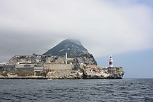
Europa Point
Southernmost point of GibraltarEuropa Point is the southernmost point of Gibraltar. Although not the southernmost point of the Iberian Peninsula, Europa Point defines the boundary between the Straits of Gibraltar in the Atlantic Ocean, and the Alboran Sea within the Mediterranean. At the end of the Rock of Gibraltar, the area is flat and occupied by such features as a playing field and a few buildings. On a clear day, views of North Africa can be seen across the Strait of Gibraltar including Ceuta and the Rif Mountains of Morocco; as well as the Bay of Gibraltar and the Spanish towns along its shores. It is reached from the old town by Europa Road.
Read article
Top Questions
AI generatedMore questions
Nearby Places
Gibraltar national cricket team
Men's team representing Gibraltar in international cricket

MV Fedra

Nun's Well, Gibraltar

Europa Batteries

Harding's Battery
Artillery battery in Gibraltar

Sikorski Memorial
Monument in Gibraltar
Defensible Barracks

Europa Sports Park
Multi-purpose stadium in Gibraltar


