Erivan Governorate
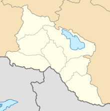
Governorate of the Russian EmpireThe Erivan Governorate was a province (guberniya) of the Caucasus Viceroyalty of the Russian Empire, with its centеr in Erivan. Its area was 27,830 sq. kilometеrs, roughly corresponding to what is now most of central Armenia, the Iğdır Province of Turkey, and the Nakhchivan exclave of Azerbaijan. At the end of the 19th century, it bordered the Tiflis Governorate to the north, the Elizavetpol Governorate to the east, the Kars Oblast to the west, and Persia and the Ottoman Empire to the south. Mount Ararat and the fertile Ararat Valley were included in the center of the province.
Read article
Top Questions
AI generatedMore questions
Nearby Places

Armenia
Country in West Asia
Civilitas Foundation
Armenian non-profit organization

Stanislavski Russian Theatre of Yerevan

Capture of Erivan

Khnko Aper Children's Library

Hovhannes Tumanyan Puppet Theatre of Yerevan

Sayat-Nova Avenue
Street in Yerevan, Armenia

Henrik Igityan National Centre for Aesthetics
Center of aesthetic education for children


