Eastern Province, Zambia
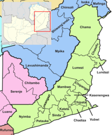
Province of ZambiaEastern Province is one of Zambia's ten provinces. The province lies between the Luangwa River and borders with Malawi to the east and Mozambique to the south, from Isoka in the northeast to the north of Luangwa in the south. The provincial capital is Chipata. Eastern province has an area of 51,476 km2 (19,875 sq mi), locally shares border with three other provinces of the country and is divided into fifteen districts.
Read article
Top Questions
AI generatedMore questions


